



Where the South ends, or in my eyes as a Mancunian, where the North begins, is a highly contested question. Some suggest that we should look back in history to find an answer, citing Shire Brook in Sheffield, the historic border between the Anglo-Saxons of Mercia and the Vikings of Northumbria, as the divide.
Others say it should be based on accent, with a line situated at the point where ‘Barth’ turns into ‘Bath’.
However, some people in Somerset have a ‘bath’ and so this would make for a skew-whiff line.
What about geographical features such as the Pennines or the abundance of industrial mines and mills as an indicator of North-South separation?
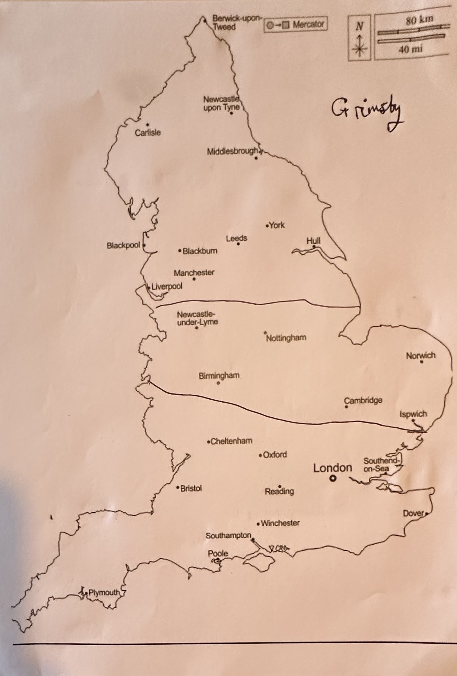
The leading academic on this perennial debate is geographer Danny Dorling. He endeavoured to decisively pinpoint a North-South dividing line by investigating disparity in life expectancy, qualifications, work-related benefit claims, rates of poverty and house prices. His conclusion was a zigzag stretching from Gloucester to Grimsby, which included the likes of Nottingham and Birmingham in the North and designated Warwick and Leicester as Southern.
An interesting judgment, but one I would argue as too heavily influenced by socio-economic variables. A more lighthearted study undertaken by Smith and Haverson used the ratio of Greggs to Pret-A-Manger shops as a telling factor to where England should be split, however their results put Cornwall and Bristol in the North and so must be met with some scepticism.
When reflecting on this research, I questioned whether the boundaries of the North can, or even should, be identified through data and statistics.
For me, being Northern is subjective, it is as much a state of mind as a geographical border.
Inspired by the pursuit of clarity and what I believe to be a distinct Northern spirit, I decided to carry out my own informal study which delved into real people’s perspectives and
opinions. My role as president of the London School of Economics (LSE) Northern Society gave me the perfect investigative opportunity.
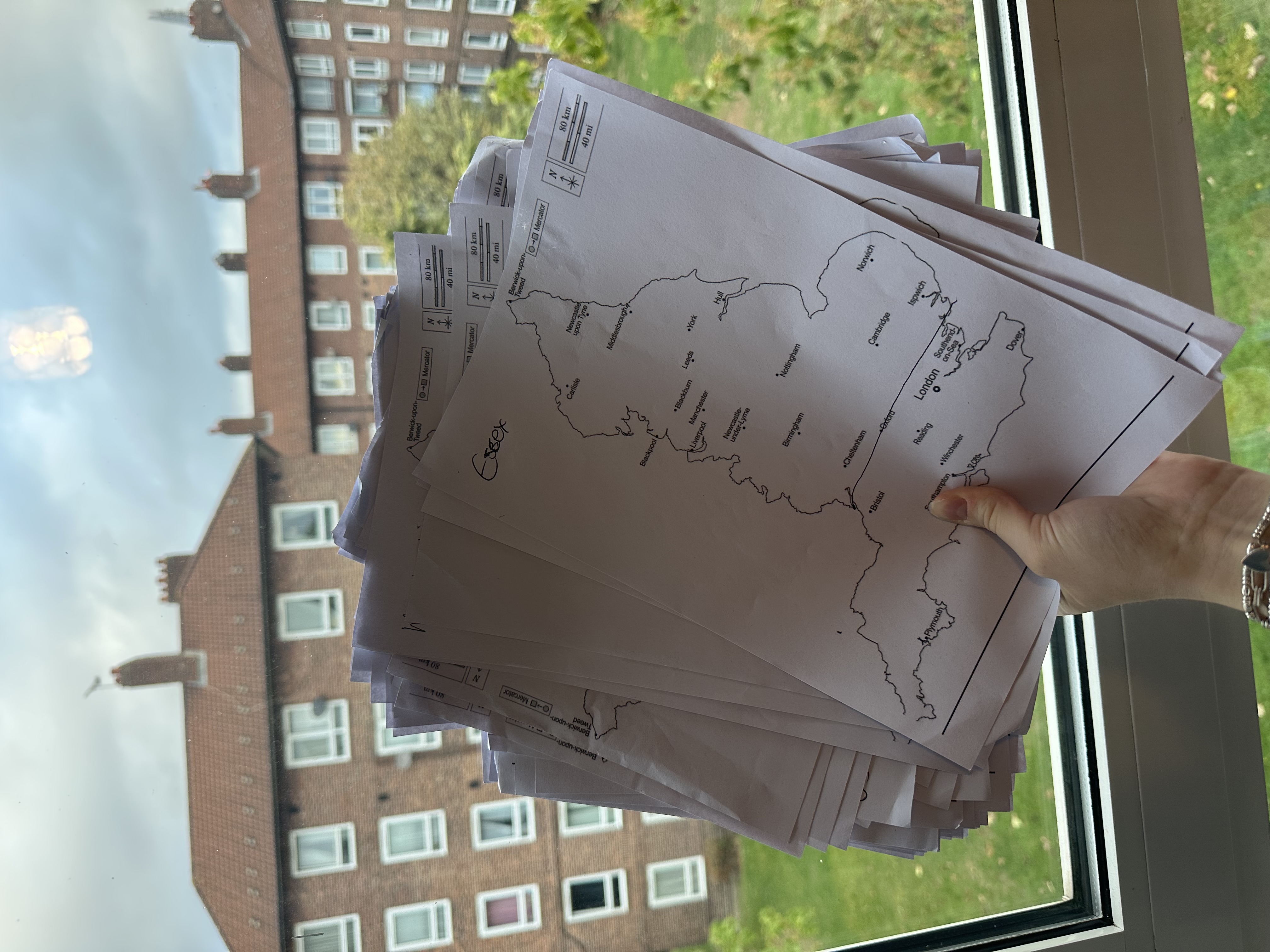
Whilst manning the Northern Society stand at my university freshers’ fair, I asked onlookers to draw where they believed the North-South dividing line to be on a blank map of England. After a busy day, I had accumulated over 75 annotated maps revealing a multitude of valuable perspectives which I separated into six different geographical groupings based on the respondent’s hometown: North West & Yorkshire, North East, ‘Debated territory’ (ie. the Midlands), the South, Greater London and finally International.
A word of caution before I proceed with my findings: the study cannot be said to represent a nationwide perspective, as the people choosing to interact with the Northern Society stand were mostly Northern and so likely had a biased opinion.
Those from elsewhere were largely indifferent to the concept of a distinct ‘North’, but were just accompanying a friend or enticed over by the Liverpool FC shirt I was wearing.
In addition, many international students who approached the stand were from Scandinavia, having mistaken North of England to mean North of Europe.
Nonetheless, my findings offer a worthwhile insight into how the North-South divide is perceived at one of the UK’s top educational institutions.
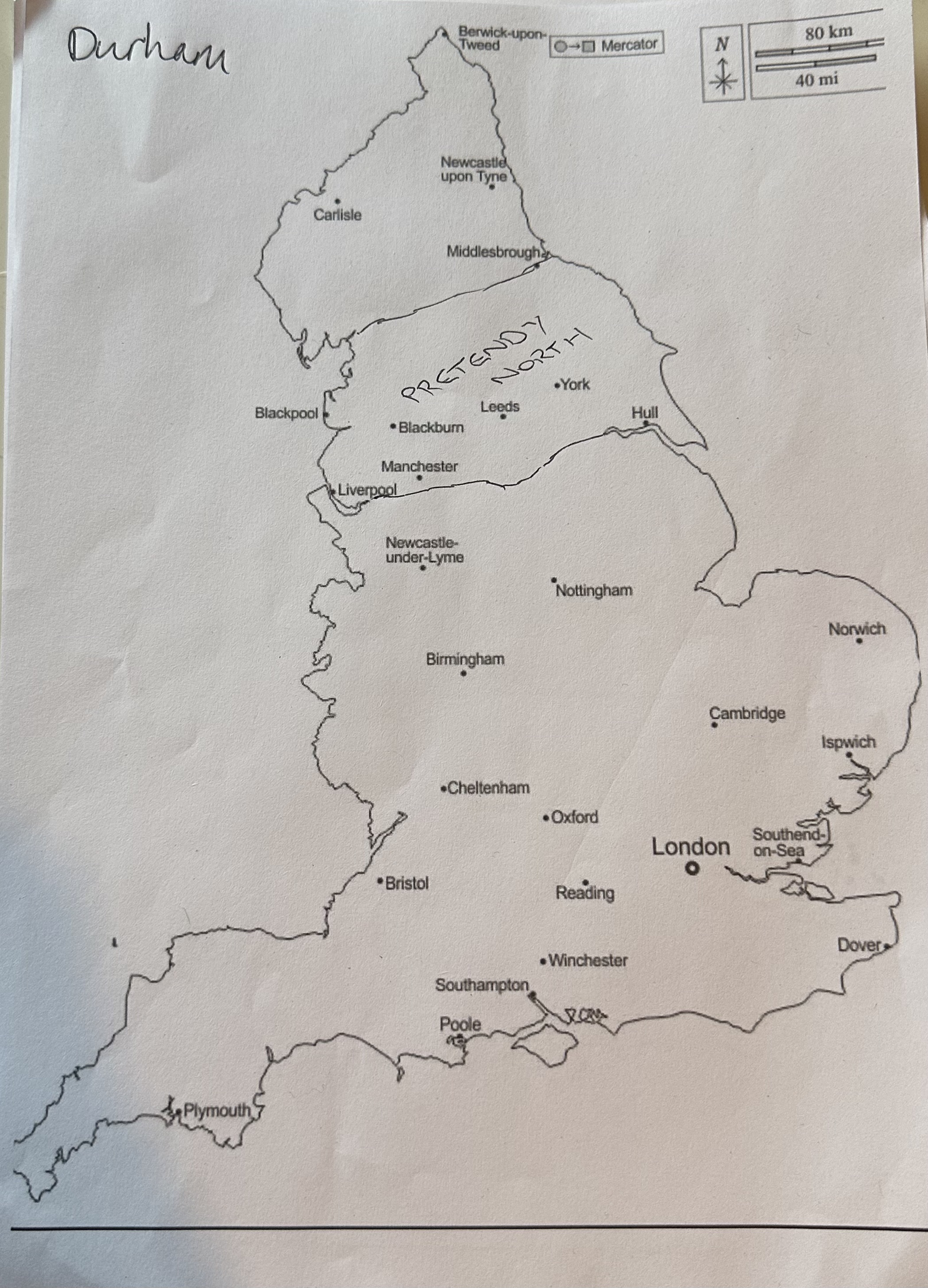
Starting the analysis with the undoubtedly Northern respondents from the North East and North West & Yorkshire. On average this group drew a horizontal dividing line roughly from Stoke to Skegness. However, it surprised me to discover that a few people native to Newcastle and the surrounding areas drew their line as far north as Blackpool to Middlesbrough, with one Durham local claiming the likes of Manchester, Leeds and York to be, in his words, “pretendy North”.
This disunity is not shocking; the North East has always had a strong regional identity, one that was put to the test in 2004 through the North East regional assembly referendum. I would argue that my results 22 years later, may have been influenced by the rise of Burnham’s ‘Manchesterism’ and Number 10 North.
Perhaps the economic and political frustrations those from the North West have historically had with London and the South, may also exist internally within the North, with North Easterners feeling left behind in this new age of devolution.
Moreover, most respondents in the ‘Debated territory’ grouping placed their line below Nottingham and Birmingham, and by doing so, claimed a Northern identity.
This contradicts a national YouGov study, which found that 78% of West Midlanders and 69% of East Midlanders saw themselves as living in neither the North nor the South.
My differing results may partly reflect the setting; with no Midlands Society at the freshers fair, there was no obvious home for a distinctly ‘Central England’ identity.
They also reflect the exercise itself. Only one respondent deviated from the ‘single North-South line’ brief by drawing two lines to create three regions. If my study had been more flexible, the YouGov data suggests more respondents would have pinpointed a Midlands region.
There was an interesting distinction between the South and Greater London samples, with Southerners placing their line far lower than Londoners. My theory behind this pattern is that Londoners, who live in a unique metropolitan bubble, may be more detached from the whims of the North-South debate and so, in the absence of strong opinion, just copied their Northern friends or drew a line splitting the country into two even halves.
By contrast, Southerners from the Home Counties or the South coast have a greater stake in the debate and so provided a more emotionally driven response. They asserted Southern exclusivity by drawing a line cutting somewhere through the Cotswolds, with one Essex native going so far as to claim Northern status for Oxford and Cambridge.
With LSE being a global university, there were lines drawn by people from all over the world within the International grouping, with most drawing the boundary from the Severn Estuary across to the Wash (arguably more “accurate” according to academic sources than many of the responses from domestic students).
However, the significant difference was that, rather than a zig-zagged line taking into consideration different cities or regions, international students, with a less intricate understanding of English geography, just drew a straight, unforgiving line.
This binary attitude may lack nuance, but would answer the debate with greater certainty than other more complex attempts.
My favourite line of the day was drawn by a Dutchman who amusingly misread Norwich as ‘Northwich’ and so used said city to construct his divide.
So, where does the North begin? After 75 maps, I am no closer to a definitive answer, but I now suspect that is the point.
The lines I collected tracked self-image far more closely than geography. Respondents disagreed over whether Manchester is "pretendy North", whether the boundary sits as far south as Oxford, and whether a Midlands identity exists at all.
Therefore, I conclude by arguing that where people place the boundary says more about who they want to be than where they live. That is why no historian's border, geographer's zigzag or ratio of Greggs to Pret will ever settle the debate. A line this contested will be redrawn, time and again, by whoever is holding the pen.
Bibliography
Cumber, Robert. "Where Does the South End and the North Begin? The Public Have
Spoken and the Lines Have Been Drawn." Yorkshire Post, June 27, 2025.
Difford, Dylan. "Based on Where They Live, How Do English People Draw the Borders between North and South?" YouGov, January 9, 2026.
Dorling, Danny. "Persistent North-South Divides." In The Economic Geography of the UK, edited by Neil M. Coe and Andrew Jones, 12-28. London: SAGE, 2010.
Smith, Robin, and Kristian C. Z. Haverson. "The Greggs-Pret Index: A Machine Learning Analysis of Consumer Habits as a Metric for the Socio-Economic North-South Divide in England." April 1, 2023.





